A classic northern Taiwan day hike. I have done this ridge walk many times and still love it every time. This strenuous walk starts in Shiding, climbs to a crest and then follows it for several hours. There are multiple tricky sections using fixed ropes that require hands and feet but it's not too difficult for experienced hikers. The trail is well-maintained. This is a typical ridge walk with lots of ups and downs and roots and rocks. Mostly it is in the shade but sometimes emerges onto the bare rocky spine. Even on the hottest of days, there is usually a nice breeze flowing over the ridge. This is a fun, challenging walk with amazing views of the green-blue ridges fading into the distance all along the way.

Distance/Time: 10.5 km/ 9 hours 7 minutes. More information as well as a map can be found here
This hike could probably be done in about 7 hours. My duration active was actually 6 hours 20 minutes. We took several long rests and one member of our group had not done a hike of this difficulty or length before so I had to wait after difficult sections or at crossroads. No complaints though, he kept going: slow and steady and was smiling the whole day.
What to bring: I took snacks and plenty of water. It was a hot day and there is nowhere to get water until you come down from the ridge. I took a full 3 liter Nalgene Canteen plus another regular sized Nalgene bottle and finished it all (though I did share a little). I took my hiking pole, but because I was using my hands a lot, it spent most of the day attached to my pack. The trail is wide and shorts are fine but I wore long sleeves and a hat for sun protection.
The Trail:
This is a hard hike but the trail is well-maintained (foot holds cut into rock, ropes in steep or tricky spots), and not too difficult for fit, experienced hikers. The views are amazing and I enjoyed it so much that sometimes I found myself smiling in excitement at the pure beauty of it. It's a popular hike so we saw plenty of other hikers. We saw some of the same hikers throughout the day and everyone was very friendly and relaxed.
We went after two days of heavy rain and shaded part of the trail was very slippery. One member of our group fell and I saw two other hikers who fell. On the day we went it was 33 degrees and humid so that made it feel more difficult.
The trail starts out kind of easy but after passing a farm house there is a tough 20 minute climb to the top of the ridge. From there the trail passes over Ximaozi (West Hat Rock, 480 m) and later Bijiashan North (580 m) and South (585m) Peaks. After Bijiashan it starts to head down. It is very easy to find the way. Just follow the main path all the way, ignoring side paths, all the way to the crossroad with the trail to Ergeshan.
At the crossroads for Ergeshan, we went on to Monkey Mountain (Houshanye) main (552 m) and front (510 m) peaks and then descended to the Zhinan Temple Gondola Station.
The last part going over Monkey Mountain is much easier but it felt long because we were tired. Taking the Maokong Gondola down to the Taipei Zoo MRT station is a great way to finish the hike but if that seems too long, there is a shorter option.
Shorter option:
At the crossroads for Ergeshan and Houshanye turn right toward the Houshanyue trail and then take the next trail on the left. This should lead to Zhinan road. Walk on Zhinan road for about 800 meters to the Caonan Banyan Tree bus stop. Here you can take the S10 to Wanfang Community MRT station. This bus runs about every 40 minutes. This would shorten the walk by roughly 3k and cut out the final two peaks of Houshanye.
Transportation: I took the MRT to Jingmei Station exit 2, crossed the street and walked straight down Jingzhong street to the bus stop in front of Jingxing Park. It was a good place to wait for my friends because the park was shady and there were convenience stores nearby.
We took bus 666 at 7:48 to Shiding. There are three different 666 routes but they all stop at Shiding. Check the bus times on the BusTrackerTaiwan app. The ride to Shiding took about 50 minutes. Lots of people got off there and the driver announced the stop. There is a Hi-Life in Shiding near the bus stop.
On the way back we planned to take the gondola from Zhinan Temple Station down the Taipei Zoo MRT. It would have been the perfect way to finish the hike. Unfortunately, I did not know the gondola was closed for maintenance for two weeks. It is scheduled to open again on June 21, 2023.
So that was a big disappointment. We tried to call an Uber but it never showed up. So after waiting fruitlessly my friend made some inquiries and we found out we could walk down to Zhinan temple and catch a bus from there to Wanfang Community MRT station.
The hike:
We got off the bus next to a stream. After a visit to Hi-Life we started walking at 8:50. We crossed the stream over a red bridge and turned right into an alley on the other side of the stream. When looking downstream you can see a tall highway. The trailhead is under the highway.


Then we continued down the alley. It was already 30 degrees and the water in the stream looked clean and inviting.
Soon we came to a trail on the left clearly marked with a wooden signpost and lots of flags. We started up the trail with a small stream on our right. After the recent rain the stream has some nice deep pools and frothy, rushing water.
 |
| Bijiashan trailhead |

We crossed a short footbridge and continued on the other side of the stream. At a crossroads, after a steep incline, we turned left and started passing through a farm.


We came to a stone farmhouse. In the past, every time I had been here the farmer offered a cup of tea but this time no one seemed to be home. The trail continued to the right of the farm house and climbed beside its roof.


After the farm house there was a very steep twenty minute climb to the ridge.

During the climb I was passed by a solo hiker. I would not see her again all day. But I passed a couple and then at the top met another group of four. Throughout the day I would meet the couple and the group of four at rest stops. Everyone was very friendly and we chatted in a companionable way all day.
At the top of the ridge we stopped for a well-earned rest. There was a white sign with a red "1" on it. There are ten of these on the hike and its a handy way to keep track of your progress. The path went right. We had 9 more signs to go plus the final part to Monkey Mountain so we set off.


We came to some narrow steep parts where we caught up to the group ahead of us.
 |
| The group of four ahead of us climbing a steep section |

Next we ran into a bottle-neck. There was a short but very steep and slippery descent down a rock face. The couple I had met earlier and the group of four were all here and one woman was having a hard time with it and everyone was offering advice. I decided it was a good time to stop for a snack. Then after they had gone we went on.


About 40 minutes after Ximaozi, we came to a rest area with benches at a sort of crossroad. We stopped for a while, talking to the other hikers and another hiker, coming from the opposite way, stopped to chat. This was number 5 on the sign count. There seemed to be a path going right but it was not very clear. The path to Bijiashan was along the ridge to the left.


Finally, we took an eroded rocky section of trail around a point next to a ravine and came up a slope to the rest area at the base of Bijiashan.

 | |
| Looking up at the rest area at the base of Bijiashan--number 8 on the sign count |
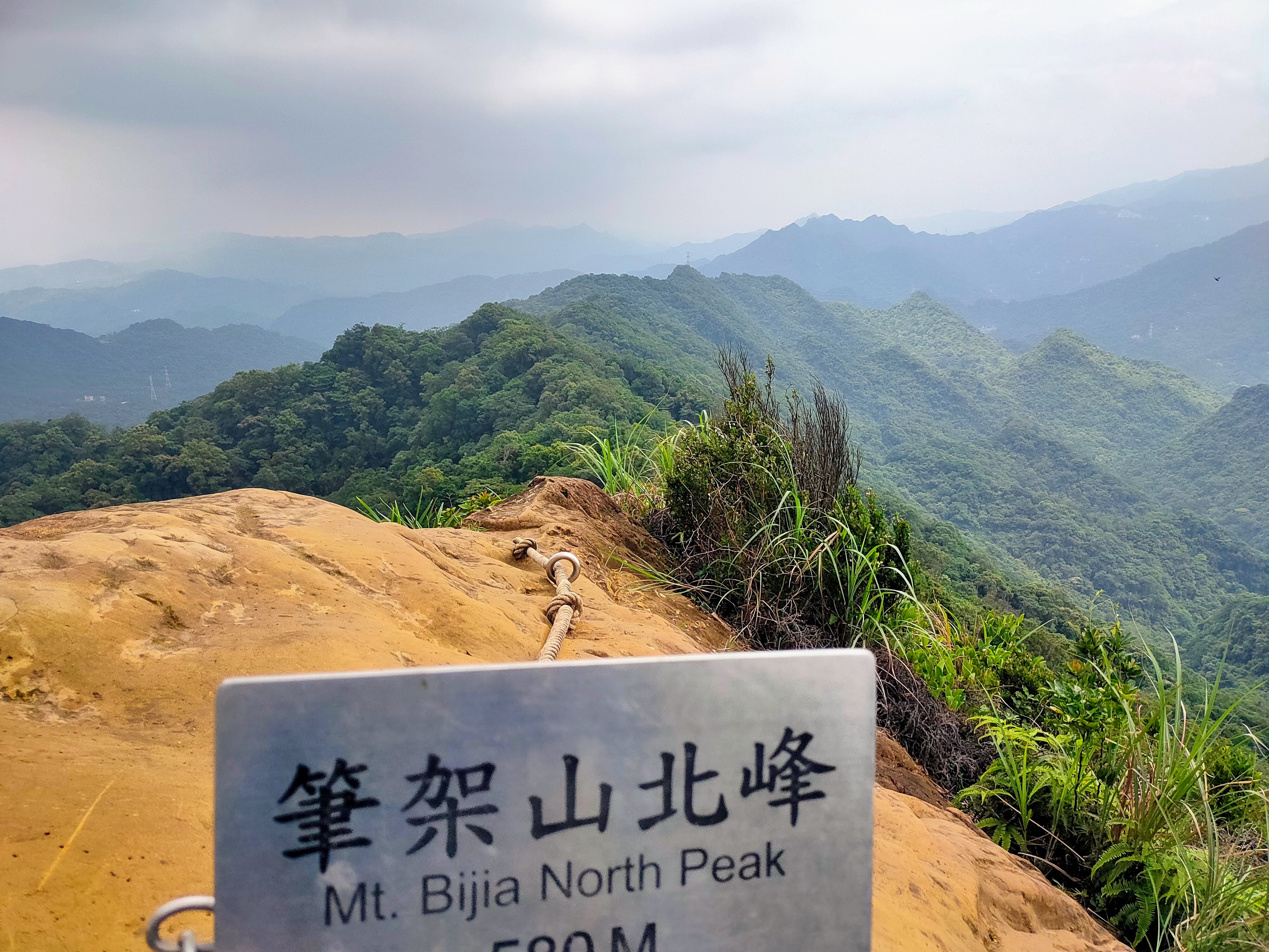
There is a must-see, 360 degree view from Bijiashan North Peak which is reached by a short-rocky climb on the right. We got to Bijiashan 5 hours after starting the hike.
 | |
| Bijiashan North Peak |
As we were on the peak some dark scary clouds were moving in. We decided to eat something in case we got drenched later and so we would not have to eat in the rain. But luckily after about ten minutes the clouds moved on and the sun came back out.
Another side trail (only 10 meters in length) goes to the south peak. It is not as exciting as the north peak but worth seeing if you came all this way.


Not long after, we came to the crossroads for the trails to Ergeshan and Monkey Mountain (Houshanye). There were lots of people there because Ergeshan is popular. We took a right.


At first, we were walking behind two ladies and eventually passed them. When we came to a trail on the left we kept going straight. The left fork goes to Zhinan road and also curves around to rejoin the main trail later. There were some steep sections but it was easier than the Bijiashan trail.

 |
| We went straight at this fork |

 |
| The side trail rejoined the main path and we turn right following the signs for Houshanyue Main Peak |
We crossed the road and came to a fork and turned left. There were several intersections on the trail but we followed the signs for Houshanyue Main Peak.


The trail went over a rocky knoll and then passed three intersections.

At the first intersection we stayed straight.

At the next, Y-shaped, intersection we took the left fork.

The third intersection was the last before reaching Houshanyue. We went straight. The right fork leads down to the Lin Family Cottage and Shenkeng. I had hiked this trail in October of the previous year.
 |
| Here it's straight to Houshanyue (Monkey Mountain), right to the Lin Family Cottage and Shenkeng |
From here it was less than 1 km to Houshanyue Main Peak. This is a nice, wide, level trail. We saw two troops of monkeys but the mountain is actually called Monkey Mountain because it is thought to look like a monkey's head from below.

Houshanyue Main Peak is not very exciting and we wanted to finish the hike so we passed right by it.
 |
| Houshanyue (Monkey Mountain) Main Peak |

The front peak is a little further on and offers a great view of the city. I had taken the short walk from Zhinan Temple Station to here a few months before to see the sunset and the lights of the city at night.

We were all tired and took a short rest but it was getting late, so we pushed on after a while. It's just 1.2 km from here to Zhinan Temple Station. The descent is very steep but it is short and there are lots of hand and footholds.


We came to a restaurant with a metal roof, a row of red lanterns hanging above the entrance and a statue of Guanyin in front. There are always lots of cats around this restaurant and there are two small dogs at the house across the street that bark but which won't bother you. Next to the restaurant there was trail and we turned right.

Then it was just a matter of following this trail (ignoring a turn on the right) down steps and to a road. At the road we turned right, went through a red archway and came to Zhinan Temple Station.


Monkey Mountain 猴山岳, the Lin Family Cottage and Four Dragons Waterfall 四龍瀑布
Four Dragons Waterfall 炮仔崙瀑布(四龍瀑布)
Monkey Mountain 猴山岳 Sunset Hike
Similar walks:
Jinmianshan 金面山 to Baishishan 白石山 Ridgewalk and the Datieliao Historical Trail 打鐵寮古道
Subscribe: To get new posts by email you can subscribe here Subscribe or follow Taiwan Hiking Journal on Facebook
Map and GPS coordinates:
Bijiashan North Peak: 24.975062, 121,630502
Houshanyue Main Peak: 24.976692, 121.60044
Houshanyue Front Peak: 24.978809, 121.599099
.png)
No comments:
Post a Comment