

Distance/duration: 10.9 km/ 5 hours 50 mins.
Driving to the trailhead and just walking to the waterfall would make the hike only about 4 km.
From Houdian bus stop to the waterfall and back is about 9 and a half kilometers. My hike was longer because I went further upstream of the falls before going back.
More details as well as a map can be found here on my ramblr account.
What to bring: In Houdian there is a small shop but it just sells a few drinks. It's better to pack anything you need ahead of time.
I packed lunch and snacks and two liters of water. It was a hot day and I also treated and drank some water from the waterfall. (My filter is broken so I used iodine).
The Trail: My hike started with a road walk along country roads. I took a shortcut to cut out a large bend of the road and then arrived at the main trail to the waterfall. After that I walked above the falls looking for some ruins.
The road walk was nice and there was lots to see. I don't mind walking on roads and consider it part of hiking and not a prelude to the hike.
The shortcut that I took was slightly confusing but if you have an offline map, it's not that hard to find the way.
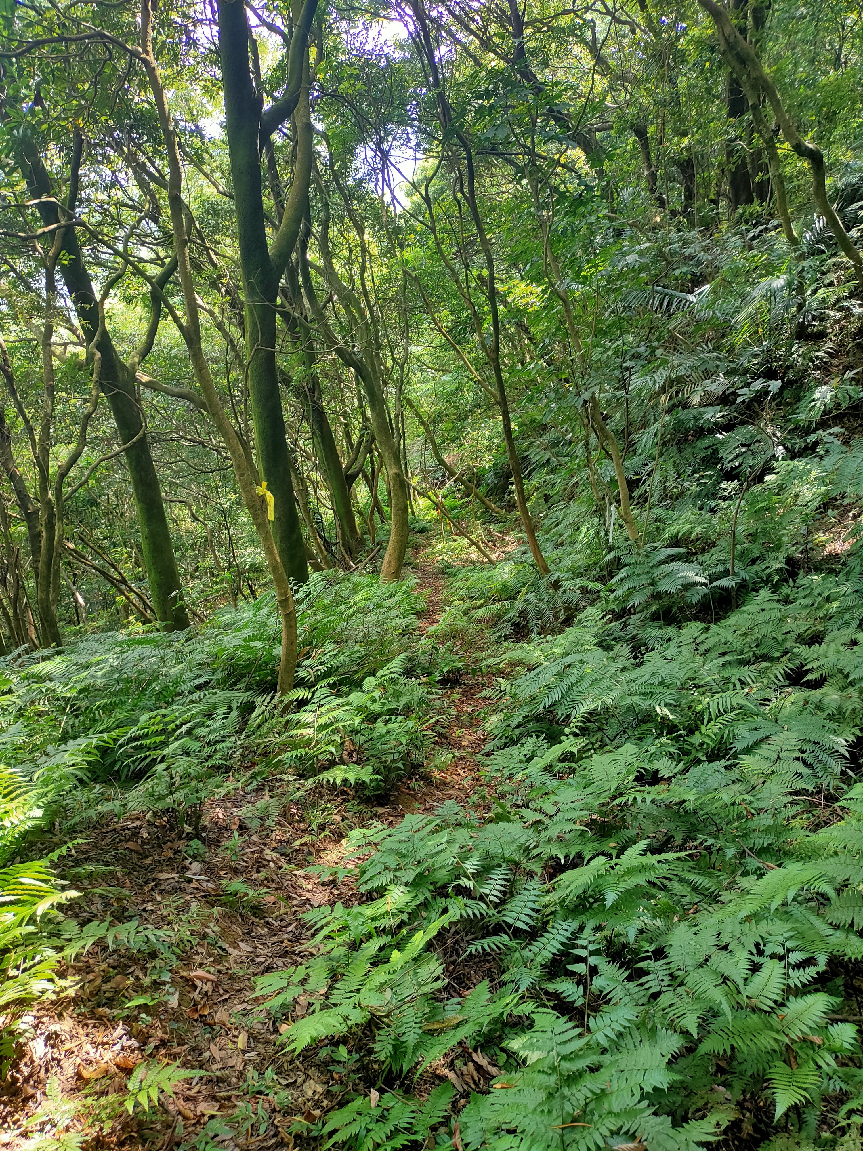
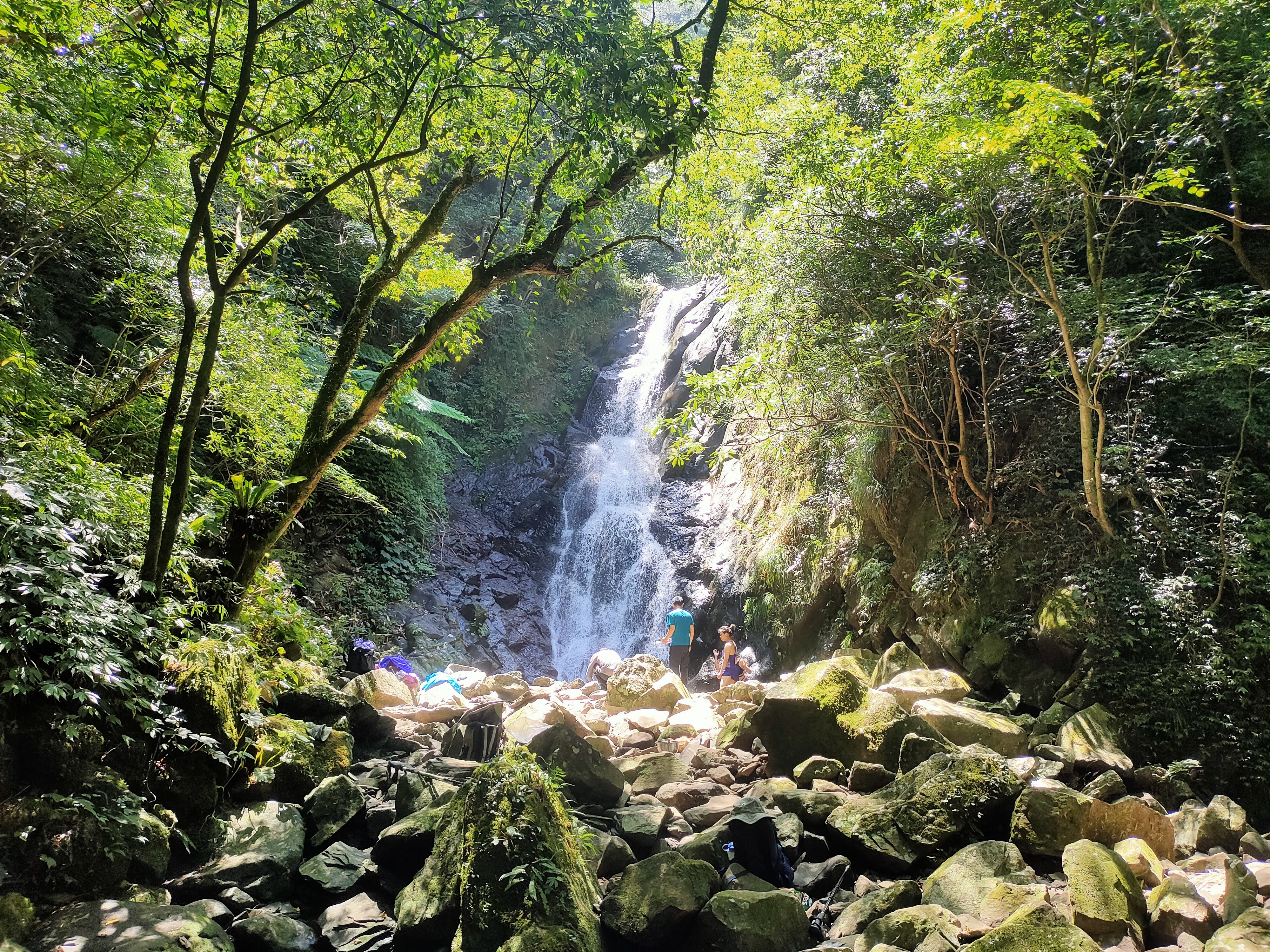
Red Leaf Valley Waterfall (Hongyegu Pubu) is also known as Neiganzhai Waterfall.The main path to the waterfall is easy to follow and very pleasant. There is one stream crossing. Near the top it gets steeper, narrower and more rocky but it is never very hard. The waterfall itself is spectacular. The water plunges into a dark, deep-looking pool but there are shallow areas of crystal clear water around the edge that are great for soaking your feet. The water felt cold even on a hot day.
The path that I took above the falls was treacherous: narrow, steep and often next to a big drop. I walked until the path recrossed the main stream. It was a nice spot but the ruins were underwhelming and I wouldn't recommend going up unless you just feel like doing some more exploring.
The waterfall is near the Lujiaokeng Ecological Protection Area. You need a permit to enter the nature reserve but don't need a permit for the waterfall.
Route landmarks: Houdian bus stop -- Yuanshan Village Liansong No. 2 Bridge --shortcut trail entrance -- Red Leaf Valley Waterfall trail head -- stream crossing -- Red Leaf Valley Waterfall
Transportation: I took the MRT to Tamsui and then took bus 876 to Houdian. This bus shuttles between Tamsui and Sanzhi. It departs at Tamsui at 6:00, 9:30, 11:40, 15:10 and 17:15.
I took You Can't Go Home Again by Thomas Wolfe for the ride.
You can also take bus 866 but it only runs once a day, leaving Tamsui at 8:45.
Both bus stops are near exit 2 of the MRT station.
On the way back, I caught the 15:10 876 on its way back to Tamsui at 16:10.
Subscribe: To get new posts by email you can subscribe here Subscribe or follow Taiwan Hiking Journal on Facebook
The walk: I got off the bus just a little after ten and started hiking at 10:12. Turning back in the direction of Tamsui, I took a smaller road forking left and uphill. This was 北 11.

Coming around the first bend I could see True Dragon Tower high on a hill. It is the largest columbarium in the world; designed to hold the ashes of 400,000 people. An article I came across described it as a "hotel for the dead."

After just five minutes the road split and I took the right fork. I passed a colorful, little Earth God shrine by the side of the road.
 | ||||||
| I took the right fork here. |
 |
| Tudigong Shrine |

Just 25 minutes after I started I came to Yuanshan Village Liansong No. 2 Bridge. There was a blue sign with the name of the bridge indicating it was an emergency rendezvous point in the case of a nuclear power point emergency.

On the other side of the bridge I turned right and faced a wide area with a green metal shed between two roads. The green building seemed to be a temple or a place for storing temple paraphernalia. I took the road on the left and went uphill and around a bend. Around the bend there was another fork and I took the right fork.
 |
| left at the green metal building |
 |
| I took the right fork here. |
This was a nice shady road which after a while brought me to the trail I was looking for--a short-cut to the main trail for the waterfall.

 |
| trail entrance for the "short-cut" |


I came to a wider path that was leaf strewn and grassy and turned left.


The path to the waterfall trailhead is clear. It is the first clear, path on the right, heading downhill. It just took a few minutes to find it.


After about 20 minutes I came to a pretty stream crossing.


There is one place where the path forks but both routes join together later. I took one way on the way there and the other on the way back.
I passed several old stone walls. I passed the clearing next to indigo extraction pits. Though the indigo dye industry in Taiwan experienced a resurgence during WWII when industrial dyes where hard to get, it pretty much died out once industrial, synthetic dyes were available. There were a lot of people eating and talking at the clearing. I kept going to the falls. The closer I got to the waterfall the narrower and stonier the trail became.
There was a large, noisy group at the waterfall. A group of four hikers --two men and two women-- arrived after me and one of the men struck up a conversation in English. He had just come back from a trip to Washington D.C. The big group headed back down and then it was just the five of us at the waterfall.


The ruins are where the path crosses the main stream again. I don't know what the story behind them is but all I saw were the remnants of a stone wall. I would have missed it if I had not been looking for it.

Back at the waterfall I talked with the four other hikers as well as some newcomers, washed off again and then started my hike out. I took the same route on the way back. When I took the short cut I first walked right by the trail going down to the road. Look out for two large stones. The path starts between them.

On the way I checked the BusTracker Taiwan app and realized I had cut it a little close for catching the bus. I jogged part of the way on the road and arrived with a few minutes to spare. I had a cold drink from a shop and changed out of my sweaty t-shirt. According to the app the bus was due at 16:15 but it arrived at 16:10.

Further Information:
Here is a video by Tony Huang about the trail.
Here is another video from YouTube with some beautiful images of the trail and waterfall.
Subscribe: To get new posts by email you can subscribe here Subscribe or follow Taiwan Hiking Journal on Facebook
Map and coordinates:
Houdian bus stop: 25.225237, 121.51607, Google Maps link
Short-cut trail entrance: 25.21652, 121.531012
Hongyegu Waterfall trailhead: 25.215975, 121.534992, Google Maps link
Hongyegu Waterfall: 25.203985, 121.544679, Google Maps link
.png)
No comments:
Post a Comment