Wednesday, March 16, 2022

Nuandong Valley Park 暖東峽谷, the Xishikeng Old Trail 西勢坑古道 and Xishi Reservoir 西勢水庫


Hiking along the Xishi Stream


Luxuriant jungle-like forest, a beautiful, swift-flowing stream with many deep pools and a path around a large placid reservoir. This route starts at a park in Nuandong Valley, climbs a small peak, then drops down to follow the Xishi stream all the way to the Xishi Reservoir before finishing at Nuannuan Train Station. This was a new hike for me and one of my favorites so far this year. It is also convenient to get to from Taipei.

 Distance/Time: 8.4 km/ 6 hours and 24 minutes

The Trail: The trail starts out in a manicured park with wide paths but soon leaves it behind for wilder paths. The trail was in good shape and there were signs that some pretty heavy duty trail maintenance had taken place. The footing was mostly good but some parts were slow going because of slippery rocks and scrambling over boulders. It was not steep overall or strenuous but there were many short steep sections both up and down and enough places where we had to use both hands and feet to make it really interesting. 

Overall I think this trail falls somewhere between a moderate hike and a hard hike. There are plenty of rough sections but its not too hard. However, inexperienced hikers might find some parts daunting. There were lots of shallow stream crossings. I would probably avoid this hike after heavy rain. The beauty of the forest and the stream and the variety of scenery made it a really enjoyable walk.

What to bring: I packed water and lots of snacks. The trail was mostly in shade but there were also quite a few sunny sections so sunscreen and a hat are recommended on hot days. There were lots of shallow stream crossings so water proof boots are a plus as well as a hiking pole for helping to balance on rocks when crossing.

Transportation: This hike is easy to get to. There were three people in our group. We met at Taipei Main Station and took a train to Nuannuan Station which took about 40 minutes and cost NT$38.  

From Nuannuan Station I thought that we could take bus 603 to the Nuandong Valley Park. However, every time I checked the bus tracker app it did not show a bus approaching the station and when we got to the bus stop there was a group of women who told us they had been waiting for a long time. The sign at the bus stop said the bus came at 8:50 but when 8:50 had come and gone we opted to take a taxi. It was about a ten minute ride and only cost NT$150. 

On the way back we walked all the way to the train station and only had to wait about 30 minutes for a train back to Taipei.

The Hike: 

I read about this trail last summer on the Taipei Hiker blog and since then have been looking for an opportunity to walk it. You can read the Taipei Hiker blog post about this trail here: https://taipeihiker.blogspot.com/2021/07/2021717-hiking-over-small-peak-and.html 

Below is my own experience walking almost the same route--though we went a different way near the end. 

We got out of the taxi at the Nuandong Valley Park parking lot. There were toilets to the right and a wooden shelter house with benches to the left. We were ready to go but after getting our bearings, noticed there was a metal construction fence blocking the park entrance.


 After debating for a few minutes we decided there was no other way around. So we waited until no one seemed to be looking and climbed over the faux-bamboo railing on the side and went in. 

There was no one inside and anyway within a few hundred meters we were out of the park and onto the trail. We crossed a stream over a wide bridge, and passed another bridge on the left . We went straight ahead past a wooden building and came to a map board, and a little further on, the trail head. 


Flags in the trees on the right mark the trailhead

 The narrow dirt path climbed gently through shady forest.


In about three hundred meters we came to the first stream crossing--across large boulders with a rope to help keep balance. 


And very shortly came to a T-junction. The path on the left heads back toward the park. We went right and uphill. 


The trail also passed through groves of bamboo and in about 450 meters (30 minutes after we started walking) we came to another junction. We went right and soon crossed back over the stream. 


  From here the path went up more steeply. 


We passed some old stone walls and the remains of indigo extraction pits. They are mentioned in the Taipei Hikers blog and the guide of a group of hikers we met later was also telling his group about them.  Indigo (the guide called it malan 馬藍) has a purplish funnel shaped blossom. The leaves and stems were once harvested and used for producing blue dye. 

The plant was introduced to Taiwan from China during the Qing Dynasty. The indigo dye industry declined during Japanese colonial rule though it did continue among some residents who did not have access to or did not want to pay for imported dyes. However, after World War I the industry was pretty much completely gone.

This article in Chinese is very informative and has excellent photos of the plant. My Chinese is not good enough to read it in Chinese but translated using Google, it's very readable.  https://teia.tw/natural_valley_star/ph2021-12-01/

 In another 500 meters we came to a four way intersection. The path ahead and down hill was the way we would later take but first we went right and climbed to the summit of Dong Shi Da Lun (455 m). The path to the top was very narrow and steep in some places. It was a fun short climb. 


We reached the top at 10:35-- so just about an hour after we started walking. There was a large hiking group already there, all of its members wearing identical red shirts. 


Some of the members at the back of the group told us there was a friend from Scotland with them. The crowd parted and he came over to talk to us. We exchanged greetings and identified our respective countries of origin and took a picture together.  

After a few minutes the group started to move on. They were heading straight ahead. Also going to the reservoir but by a high route that goes over two more summits. We saw them again later at the end. My guess is that this is the more popular route. I would like to try it another day, however, our plan was to drop down and follow the stream to the reservoir. 

We went back down to the intersection below and at the junction went right and downhill. 

It went down sometimes steeply but sometimes leveling off.

At times the path was a little unclear and there were branches fallen across the way but we just kept an eye out for the flags. 


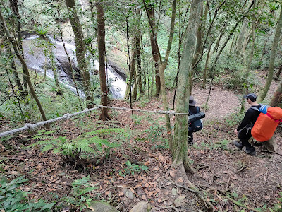
Eventually we joined a rocky ravine and the path sometimes followed it and sometimes went across it or climbed above it to avoid large drops or rock jams. As we got further down it got wetter and we were walking in shallow, flowing water. 


Looking back at a large jumble of rocks after the path went over and around them

At the bottom we joined the Xishi Stream and after crossing over stopped for a rest and a picnic lunch beside the stream just before 12:00. 


We spent almost an hour here. After lunch we turned right heading downstream with the water on our right.


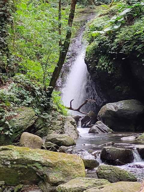
The going was slow here both because we had to climb over rocks but also because we kept stopping to admire the beauty of the stream. There were high rock walls and greenery everywhere.

In one memorable and fun part the path led us through a cleft in the rocks that was so narrow that we had to take off our backpacks and push them through first in order to squeeze through.


From here the path follows the stream all the way to the reservoir crossing the water several times and climbing up and down side channels that feed water into the main stream.

Along the way we came to a rock formation with foot holds cut into its side that a sign identified as the snail stone (Guaniu Shi). My guess is that it is thought to resemble a snail and that people climb on top of it to have their pictures taken. 

the Guaniu Shi

We also passed a ruined structure that a sign said was part of an old coal mine and a Tudigong (Earth God) shrine. Plastic rain coats like those available at convenience stores were stacked in front of the shrine for anyone who needed them and other hikers had left offerings of candy. We left our own offerings as a thanks for safety on the trail. 


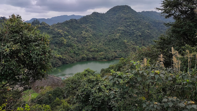
On the map the Xishi Reservoir is shaped like a fish with two "tail fins" on the southern side. When we got to the reservoir we crossed the stream below the fins and joined a trail on the other side that passed under the "fins." 


This path was wide and clear and passed through a forest of huge bamboo. At a junction we turned right and passed over a stream walking on top of a concrete dam with muddy water on either side.


Very shortly we came to another junction and turned right again.  This  path was wide and clear leading around the left side of the reservoir with views of the water through the trees. 


After walking a little more than half the length of the reservoir we took a path on the left that climbed steeply above the water and at the top we turned right along a ridge.


In just 130 meters wooden steps went sharply downhill on the left to a road. But before taking the steps it was worthwhile to walk around the corner to stand on the concrete platform of an electricity pylon that offers a great view of the reservoir from above. 


At the road we turned right passing a spacious public park with temples and croquet courts and a parking lot and later the First Branch, Taiwan Water Corporation building.

At a bridge we turned right and on the other side to the bridge turned left. We then followed this neighborhood street (stopping for a beer at Simple Mart) all the way to the railroad tracks. A right at the tracks and a short walk downhill brought us back to Nuannuan train station. 

Map and GPS Coordinates: 

Nuandong Valley Park Parking Lot: 25.07675, 121.75476

Dong Shi Da Lun: 25.069595, 121.745433 

http://rblr.co/0cMsl 


Friday, March 4, 2022

Xiong Kong Nan Shan 熊空南山 and the Xiong Kong Waterfalls


lush forest on the way to Xiong Kong Nan Shan

 
A Hua Waterfall

 A loop hike that includes lush, green forest, a shaded clearing near the summit perfect for lunch and six impressive waterfalls. The hike climbs to the summit of Xiong Kong Nan Shan from the village of Xiong Kong. Then drops down to a valley and follows the river back to the village. Overall a moderate, very enjoyable day out.

Distance/Time: About 7 hours/9.1 km. But we really took our time with a few long rests including a long time spent at the final waterfall since I was taking the last bus back home and there was no need to hurry to the bus stop. It could done in about 5 to 6 hours.

The Trail:  The hike is not too hard. It climbs fairly gently to the top of Xiong Kong Nan Shan but there are some more steep and slippery parts on the way down.

The forest on the way up is lush and the waterfalls are an impressive sight. 

Until we joined the more popular there-and-back route to Yunsen Waterfall near the end we saw few other hikers and we had the summit to ourselves. 

There are several spots near the waterfalls where its possible to soak or swim on a hot day.

What to bring: Nothing special is needed. I took my hiking pole, snacks and water. It was warm enough on this day in February to hike in a t-shirt but it was cool under the shade at the top so I was glad I also brought more layers. 

There are convenience stores in San Xia and there is a small store at the bus stop at Xiong Kong. When I was waiting to take the bus home it was closed but that is the only time I have ever seen it closed.

Transportation: I took the MRT Blue Line to Yongning station. Outside exit 1 I took bus 916 to Sanxia which takes about ten minutes. This bus comes frequently and I've never had to wait long for it.  The 916 takes highway 3 to Sanxia. I got off at Da Yong Road, the second stop after the bus exits the highway. Three of us were hiking and we met at the Hi Life on the corner.

We turned right and walked down Da Yong Road to the second bus depot on the left to catch bus 807 at 8:30 am.


 This bus leaves at 6:00, 8:30, 14:30 and 17:30 on the weekends and holidays and at 5:20, 7:00, 9:30, 12:00, 15:00 and 17:30 during the week.  The ride takes about 40 minutes (more or less depending on traffic). After Xiong Kong the bus continues on to the parking lot of the Man Yue Yuan Forest Recreation Area before going back to Sanxia. 

My friends were camping overnight nearby so on the way back I took the 5:30 bus by myself which arrived at Xiong Kong at about 6:10. To be on the safe side its best to arrive at the stop no later than 30 minutes after the bus leaves San Xia. The ride back took over an hour because of 2-28 weekend holiday traffic. 

The hike:

We started walking about 9:30. Facing away from the bus shelter we went straight, passing the shop on our right and ignoring the first two roads on the left. We stayed on the same road curving to the left past the toilet and crossed a bridge. 


On the far side of the bridge we turned sharply left and uphill. 


At the top of the road we came to a group of houses. We saw two local residents who were friendly and said good morning. 


 I assumed the trail was straight ahead but a man asked us if were going hiking and pointed out the trailhead which was to the left, in a gap between the houses. 

It went up steeply at first, then more gently. It was at first a concrete track and then later a wide gravel path which gave way to alternating wide and narrow sections. We saw what looked like derelict farmland. 


We came to a fork and took the right path but the two paths soon came back together. 


 All the way up to the summit there were numerous paths forking off from the main path. Most of them were not on the map and there were too many to document. Most of the time it seemed obvious which way to go and helpfully the side paths had limbs placed on the ground across the entrances to show they were the wrong way. We checked our position occasionally using GPS and didn't have any problem finding the right way but its worth being aware that its easy to take the wrong path and have to backtrack if not paying attention.


  I spotted this animal skull which so far I have not been able to identify it. 


 After about 45 minutes we came to a spot that on the map showed 3 different paths. The middle one is the one to the summit. I had been looking out for this split. However, on the ground only the middle one, straight ahead, was obvious.


We took the path straight ahead

After this point the trail was narrower and the forest was really, thick and beautiful. I really enjoyed walking through the deep green forest surrounded by bird song and sometimes hearing the call of a barking deer. The trail climbed high above the stream valley which was far below, on our left.


We got to the summit just after 11:00 am, so about an hour and 40 minutes after we started walking.  There was a wide clearing and just beyond it the small summit of Xiong Kong Nan Shan (909 m). After seeing the summit we went back to the clearing and had a long lunch stop. 


The path to the right of the clearing was signposted to Man Yue Yuan parking lot, we took the path straight on past the summit. 


  At a fork we went left.


 A short distance past the summit we came to the only view of the hike. There had been a landslide here before. The slope below was gouged and strewn with rocks and the overhanging edge looked crumbly so we kept a safe distance from the edge. 


 After this point the trail dropped down steeply, often with ropes in place. Sometimes it leveled off but it was always in deep shady forest. 


About an hour after leaving the summit we came to the first waterfall. A Hua waterfall is just off the main path to the right. We could see and hear the water through the trees and a walk of less than a minute brought us to the base of it. 

This was my favorite waterfall of the walk because it was such a tranquil spot, we could walk right up to the base of the falls and there was no one else there. 


Rejoining the main path we soon came to a fork. We went right. It looks like the left fork does join the main path but bypasses most of the waterfalls. 


We went down another steep section and soon came out to a wide rocky area with a small waterfall and which was at the top of another waterfall also called A Hua. I was confused as to how many waterfalls there technically are.  Some of what I took to be separate falls may just be parts of the same waterfall. I decided to call it six since that is how many I counted. 


We went carefully down a slippery rock slope and crossed to the far side over two logs lashed together. 

 There was what looked like a semi-permanent camp site with plastic tarps and a dirty tent on the far side of the stream which I thought somewhat marred the natural beauty of the place.  Later I walked up there to check it out but there were some hikers there who were uncharacteristically unfriendly for Taiwan.  I greeted them but they just nodded and looked away.


On the other side of the stream the path went left along the rocks following the stream direction and then under an arch formed by a fallen tree before rejoining the dirt path. 


Soon we came to the top of Shenshan Falls and taking a detour off the path below it there is a nice view from the bottom with a white rush of water falling into a dark rocky gap surrounded by verdant green plants. 


About 100 meters later we came to Yunsen Waterfall which at 25 meters is the largest and most impressive of the waterfalls on this walk. I have been here countless times but still love seeing it. I almost envy those who are seeing it for the first time. Its a popular spot because its accessible by a wide easy trail from Xiong Kong and there were several people here including families with children. 


 We stayed here for a while and had a nice chat with two dads who were keen to speak English and had lots of questions. 

After leaving the falls the path crosses a rushing tributary stream via a bridge made of rope and branches. It had been damaged since the last time I had been here but it was still an easy crossing. 


 From here its only about 40 minutes back to the bus stop at Xiong Kong along an easy path. 


But first we took a detour to the final waterfall, Sisters Waterfall. It is off the main path and there is a shortcut going steeply down to it on the left. Unfortunately I forgot to take a photo of the shortcut but it is obvious and joins a lower path where we turned left and then followed the sound of the water to the falls. 

If you miss the shortcut you can get to Sisters by turning left at a parking lot and then following the path at the end of the parking lot. 

Here are some photos from an earlier hike: 


 Just before arriving the path drops down very steeply and emerges near the top of the falls at a wide rocky area. 

Walking toward where the water disappears over the edge and looking to the right there is a ravine running almost parallel to the waterfall. I took a step-like path down to the ravine and then climbed down rocks to the base of the falls. 


After this it was about a 20-30 minute walk back to the Xiong Kong bus stop along the path and road. You can follow the road all the way back but there is a short cut at a bend in the road on the right.

Map and GPS coordinates:

Xiong Kong Bus Stop: 24.845395, 121.450689

Trailhead: 24.844203, 121.45032

Xiong Kong Nan Shan: 24.831118, 121.457774

Yunsen Waterfall: 24.833898, 121.465735

Sisters Waterfall: 24.840712, 121.460375

 https://www.outdooractive.com/en/route/hiking-route/xiong-kong-nan-shan-tracking-on-feb-27-2022-09-28-34/236785704/