Sunday, March 12, 2023

Monkey Mountain 猴山岳 Sunset Hike


The front peak of Monkey Mountain (Houshanyue) overlooks Taipei's Wenshan District. It is a great place to catch the sunset on a clear afternoon and to see the lights of the city coming on.  It's a short but steep 1.2 km walk to the peak from the Zhinan Temple gondola station along a concrete path and later up a steep dirt path with fixed ropes.

Distance/Time: 2.4 km/ About two hours (Only about one hour was spent walking. I spent one hour on the summit). 

It took me 30 minutes to walk from the gondola station to the peak but I went quickly since I wanted to get there before dark. On the way down, I was a little slower. My track is not entirely accurate for this hike. Near the end my speed picks up dramatically because I forgot to turn off the app until after I was already back on the gondola. A map and more info can be found here

The Trail:  

This is somewhere between an easy and a moderate hike. It starts out on a concrete track and then up steps. A short section is on a road. It's a very short walk but the last push up to the summit is very steep using fixed ropes, roots and footholds. There is plenty to hold onto but for people not used to it, it could be intimidating. Also, if you go at sunset you have to climb back down in the dark. 

Monkey Mountain (Hou Shan Yue 猴山岳) consists of 2 peaks. The main peak is 551 meters but there is no view. The front peak is shorter at 514 meters but offers an amazing view to the west. 

Here is a post about a longer loop hike that starts from Shenkeng, passes over Monkey Mountain and then goes back to Shenkeng, also passing the over-100-year-old Lin Family Cottage and a waterfall. https://taiwanhikingjournal.blogspot.com/2022/10/monkey-mountain-lin-family-cottage-and.html

What to bring:  Sturdy shoes, a jacket (because the weather was cool and windy at the top even on a warm night). A headlamp if going up at sunset. I highly recommend taking a stove and brewing a cup of tea to enjoy along with the view.

Transportation:I took the MRT to the Taipei Zoo station and then the Maokong gondola to Zhinan Temple station.

The hike:  

In October of the previous year I had done a long walk that included Monkey Mountain. I noted at the time that it was very close to Zhinan Temple station and wanted to come back on a clear evening just to see the sunset. So on a fine Saturday afternoon I set out.

I arrived at Zhinan Temple later than I expected because there had been a long line for the gondola at the zoo. It was already about 5:45 (in March) and the sun was starting to set so I set off at a pretty brisk pace, wanting to get to the top before dark.

Leaving the station I turned left on the road. 

Just down the road I passed under a red archway and immediately past it, on the left, there was a sign that read "Houshanyue Trail" next to steps.


I went up the steps which curved to the right. At the top I ignored a junction on the left and kept to the right. There were more steps, a long narrow section and then I came to an opening next to an electricity pylon where there was a nice view of the gondola station and the valley beyond. 


Then more steps. 


 I came to a road. Two stubby dogs came out of the yard across the street. They barked a lot but were harmless. On the left was what looked like a banquet hall where there were several cats.  


I turned left on the road and followed it for a few minutes until I came to a hairpin turn. 


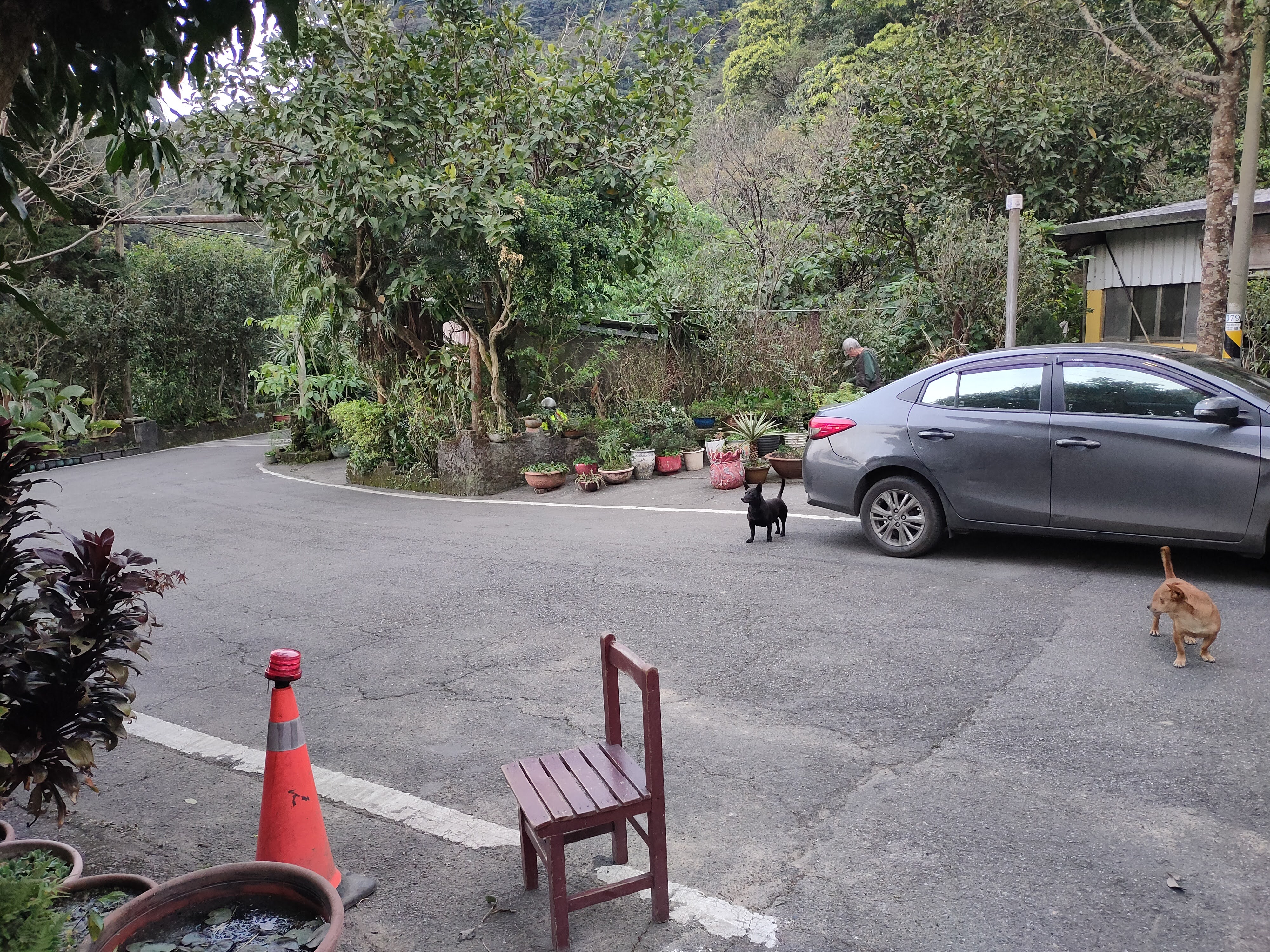
On the far side of the hairpin turn, up a side road there was a clearly marked trail.

At the top of a small rise I took the first fork on the right. It started climbing right away-- at first up steps made from local stones. Closer to the top it got dramatically steeper, almost vertical in some places with fixed ropes and footholds cut into the stone. It was a short climb.  From the start of the dirt trail, the climb took less than 15 minutes.


I got to the top just before dark. The summit is flat and there are benches. It's the perfect spot to enjoy the night view. 


It was windy and cool at the peak so I put on long sleeved shirt. I watched the light change, sent some messages to family and friends, boiled water and drank a cup of chamomile tea. I spent about an hour at the top. 


 Around 7 o'clock I hiked back down to the gondola station. The area outside the station was lit up with colorful lights and taking the gondola at night was nice, too.


Outside Zhinan Temple Station at night

Subscribe: To get new posts by email you can subscribe here Subscribe or follow Taiwan Hiking Journal on Facebook

Map and GPS Coordinates: 

Monkey Mountain (Hou Shan Yue) Front Peak: 24.978807, 121.599104


Wednesday, March 1, 2023

A Yu Road and the Tong Hou River Primitive Campground 桶後溪營地


When walking the traversing route from Wulai to Yilan hikers pass a primitive campground that lies near the end of A Yu Road -- just before reaching the beginning of the Tong Hou Trail. Ever since I walked the trail I had wanted to stay at the campground and I finally had the opportunity.  The hike from the Wulai side is on a road closed to most traffic and follows the Tong Hou River. It's a great walk for setting a brisk pace and taking in the river and mountain landscape and --if you are lucky-- glimpses of wildlife.

Distance/Time: 

Day 1: 13.5 km/ 3 hours 42 mins.  More details as well as a map here

Day 2:  19 km/ 5 hours 11 mins. More details as well as a map here

The Trail:  

This is a moderate hike.  The hike to the campground from Wulai is not difficult but is long. The trail climbs gradually uphill on the way in but its mostly level. However, walking this far with a backpack filled with camping gear is not entirely easy either. 

The road is sometimes paved and sometimes gravel and dirt. All along there are great views of mountains and the Tong Hou River. I read that this road was originally intended to connect to Yilan but it was abandoned to protect the river from contamination. At the village of Xiaoyi there is a manned traffic barrier. A sign says that only cars of local residents with business in the area are allowed to pass as well as local taxis but they cannot "stop" or honk. Some hikers climbing Dajiaoxi Shan 大礁溪山 take a local taxi from Wulai. Others drive to the beginning of the Tong Hou trail on the Yilan side and walk from there.

I returned to Wulai after camping because I needed to get back home sooner but carrying on to Yilan via the Tong Hou Trail is a great option. Here is my post about that hike:  

Wulai to Yilan: Ayu Road and the Tong Hou Trail 桶後越嶺步道 

What to bring: Nothing special is needed. Of course, if camping overnight bring the usually things for an overnight trip. Provisions can be bought in Wulai but after that, there is nowhere to buy anything. 

There are plenty of water sources along the road and near the campground so there is no need to carry much with you.

Transportation: 

Bus 849 goes from Xindian MRT Station to Wulai. The buses come every 15 minutes and take about 30-40 minutes. If walking all the way from Wulai it takes about 5 hours to reach the campground.

To save time (an distance) two of us met in Xindian and took an Uber all the way to the village of Xiaoyi which cost $600. There we met another friend who had driven his scooter.

On the way back two of us walked all the way back to the bus stop in the Wulai parking lot.

The hike: 

I was expecting some intermittent light rain all day but when I exited the MRT at Xindian it was already raining. My friend and I had some lunch at a convenience store and a beer and bought a few more things for camping (food, beer) at the supermarket. Then he ordered an Uber and we were on the way. 

We were dropped off just at the end of route 9 which runs south east from the main tourist street in Wulai to the village of Xioayi. Walking from Wulai to Xiaoyi along the road takes about an hour and 40 minutes. It was raining steadily and we put on rain coats and pack covers.


There were two roads on the right. Even though we had been here before we mistakenly took the lower road first. Some friendly people at a house asked where we were going and pointed us in the right direction.  We went back to the intersection and were soon on the correct road which is the higher one. 

We walked around a bend, over a bridge and came to the traffic barrier, which took about 25 minutes including the time we spent on the wrong road.


Our other friend's scooter was parked at the barrier. The guard at the barrier told us he had gone on and we caught up with him a little further on. 

From here it was about a three hour walk to the campground with the river and mountains on the left and forest on the right. Once in a while a tributary stream ran down a ravine and under the road. The road was sometimes high above the river but often closer to it and there were a few short trails leading down to gravely riverbanks in wide spots in the river. We had to step aside for three or four cars on the road. As one car passed a passenger in the back rolled down the window and politely called out "sorry."


Twenty five minutes after the traffic barrier we passed a huge waterfall at the side of the road. 
 

Just about every hiker stops to take a photo of this remarkable waterfall.

A little less than an hour later we came to another land mark, a tributary stream with terraced concrete weirs, the topmost one with round pipes piercing it.  


 It rained most of the time we were walking. It stopped a few times raising my hopes but by the time we reached the campsite just at dusk it was raining heavily. 


Just before arriving at the campsite the road appears to split. However the right fork soon leads to a closed gate and the left fork carries on. 


 Just a few minutes after the fork we came to what we took to be a hydro electric plant. 

The camp site is reached by going around the electrical plant on its right side, along a muddy trail.
 
It was dark, cold and wet when we arrived so I took this photo of one of two camping clearings the next morning.

The rain showed no sign of stopping so we set up our tents inside an abandoned concrete building. There was a door-less doorway and three glass-less windows. The tile floor was covered with soft, powdery dirt. It felt like a luxurious haven on a rainy night. Other people had obviously stayed here before. Cord was strung across the ceiling, there were the remnants of a campfire and a trowel was hanging on a nail outside the front door. Instead of going down to the river for water in the rainy dark, we collect water running off the roof.


We had some beers and cooked dinner. I love to turn in early when I am camping so I went to bed but my friends stayed up later talking and listening to music. I had a great night's sleep. I only woke up a few times but whenever I did I could still hear the sound of rain. 

I got up at six, walked around a little and went down to the river to collect water for coffee. 


It wasn't raining but it was misty and wet and sometimes dark clouds were passing over. We had considered doing some more hiking but because of the weather we had a leisurely morning instead and then finally packed up for the walk back to Wulai which took just over 5 hours. 


Subscribe: To get new posts by email you can subscribe here Subscribe or follow Taiwan Hiking Journal on Facebook

Maps and GPS Coordinates: 

Beginning of A Yu Road in Xiaoyi: 24.849598, 121.586536

Traffic Barrier on A Yu Road: 24.846098, 121.584463

Tong Hou River Campground: 24.836238, 121.646928

Day 1 http://rblr.co/Ohx4s


Day 2 http://rblr.co/Ohx53