 | |
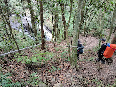
| lush forest on the way to Xiong Kong Nan Shan |
 |
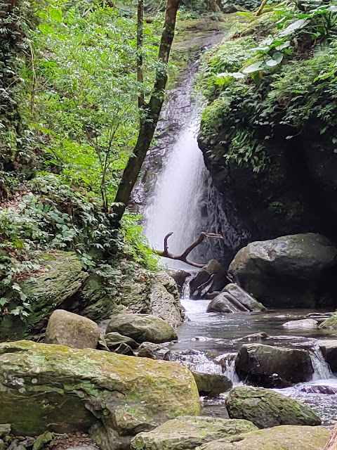
| A Hua Waterfall |
A loop hike that includes lush, green forest, a shaded clearing near the summit perfect for lunch and six impressive waterfalls. The hike climbs to the summit of Xiong Kong Nan Shan from the village of Xiong Kong. Then drops down to a valley and follows the river back to the village. Overall a moderate, very enjoyable day out.
Distance/Time: About 7 hours/9.1 km. But we really took our time with a few long rests including a long time spent at the final waterfall since I was taking the last bus back home and there was no need to hurry to the bus stop. It could done in about 5 to 6 hours.
The Trail: The hike is not too hard. It climbs fairly gently to the top of Xiong Kong Nan Shan but there are some more steep and slippery parts on the way down.
The forest on the way up is lush and the waterfalls are an impressive sight.
Until we joined the more popular there-and-back route to Yunsen Waterfall near the end we saw few other hikers and we had the summit to ourselves.
There are several spots near the waterfalls where its possible to soak or swim on a hot day.
What to bring: Nothing special is needed. I took my hiking pole, snacks and water. It was warm enough on this day in February to hike in a t-shirt but it was cool under the shade at the top so I was glad I also brought more layers.
There are convenience stores in San Xia and there is a small store at the bus stop at Xiong Kong. When I was waiting to take the bus home it was closed but that is the only time I have ever seen it closed.
Transportation: I
took the MRT Blue Line to Yongning station. Outside exit 1 I took bus 916 to Sanxia which takes about ten minutes. This bus comes
frequently and I've never had to wait long for it. The 916 takes highway 3 to
Sanxia. I got off at Da Yong Road, the second stop after the bus exits the highway. Three of us were hiking and we met at the Hi Life on the corner.
We turned right and walked down Da Yong Road to the second bus depot on
the left to catch bus 807 at 8:30 am.
 |
This bus leaves at 6:00, 8:30, 14:30 and 17:30 on the weekends and holidays and at 5:20, 7:00, 9:30, 12:00, 15:00 and 17:30 during the week. The ride takes about 40 minutes (more or less depending on traffic). After Xiong Kong the bus continues on to the parking lot of the Man Yue Yuan Forest Recreation Area before going back to Sanxia.
My friends were camping overnight nearby so on the way back I took the 5:30 bus by myself which arrived at Xiong Kong at about 6:10. To be on the safe side its best to arrive at the stop no later than 30 minutes after the bus leaves San Xia. The ride back took over an hour because of 2-28 weekend holiday traffic.
The hike:
We started walking about 9:30. Facing away from the bus shelter we went straight, passing the shop on our right and ignoring the first two roads on the left. We stayed on the same road curving to the left past the toilet and crossed a bridge.


On the far side of the bridge we turned sharply left and uphill.

At the top of the road we came to a group of houses. We saw two local residents who were friendly and said good morning.

I assumed the trail was straight ahead but a man asked us if were going hiking and pointed out the trailhead which was to the left, in a gap between the houses.

It went up steeply at first, then more gently. It was at first a concrete track and then later a wide gravel path which gave way to alternating wide and narrow sections. We saw what looked like derelict farmland.


All the way up to the summit there were numerous paths forking off from the main path. Most of them were not on the map and there were too many to document. Most of the time it seemed obvious which way to go and helpfully the side paths had limbs placed on the ground across the entrances to show they were the wrong way. We checked our position occasionally using GPS and didn't have any problem finding the right way but its worth being aware that its easy to take the wrong path and have to backtrack if not paying attention.

I spotted this animal skull which so far I have not been able to identify it.


After about 45 minutes we came to a spot that on the map showed 3 different paths. The middle one is the one to the summit. I had been looking out for this split. However, on the ground only the middle one, straight ahead, was obvious.

 |
| We took the path straight ahead |
After this point the trail was narrower and the forest was really, thick and beautiful. I really enjoyed walking through the deep green forest surrounded by bird song and sometimes hearing the call of a barking deer. The trail climbed high above the stream valley which was far below, on our left.


At a fork we went left.

A short distance past the summit we came to the only view of the hike. There had been a landslide here before. The slope below was gouged and strewn with rocks and the overhanging edge looked crumbly so we kept a safe distance from the edge.

After this point the trail dropped down steeply, often with ropes in place. Sometimes it leveled off but it was always in deep shady forest.


This was my favorite waterfall of the walk because it was such a tranquil spot, we could walk right up to the base of the falls and there was no one else there.


We went down another steep section and soon came out to a wide rocky area with a small waterfall and which was at the top of another waterfall also called A Hua. I was confused as to how many waterfalls there technically are. Some of what I took to be separate falls may just be parts of the same waterfall. I decided to call it six since that is how many I counted.


We went carefully down a slippery rock slope and crossed to the far side over two logs lashed together.
There was what looked like a semi-permanent camp site with plastic tarps and a dirty tent on the far side of the stream which I thought somewhat marred the natural beauty of the place. Later I walked up there to check it out but there were some hikers there who were uncharacteristically unfriendly for Taiwan. I greeted them but they just nodded and looked away.


Soon we came to the top of Shenshan Falls and taking a detour off the path below it there is a nice view from the bottom with a white rush of water falling into a dark rocky gap surrounded by verdant green plants.


We stayed here for a while and had a nice chat with two dads who were keen to speak English and had lots of questions.
After leaving the falls the path crosses a rushing tributary stream via a bridge made of rope and branches. It had been damaged since the last time I had been here but it was still an easy crossing.

From here its only about 40 minutes back to the bus stop at Xiong Kong along an easy path.


But first we took a detour to the final waterfall, Sisters Waterfall. It is off the main path and there is a shortcut going steeply down to it on the left. Unfortunately I forgot to take a photo of the shortcut but it is obvious and joins a lower path where we turned left and then followed the sound of the water to the falls.
If you miss the shortcut you can get to Sisters by turning left at a parking lot and then following the path at the end of the parking lot.
Here are some photos from an earlier hike:


Just before arriving the path drops down very steeply and emerges near the top of the falls at a wide rocky area.


After this it was about a 20-30 minute walk back to the Xiong Kong bus stop along the path and road. You can follow the road all the way back but there is a short cut at a bend in the road on the right.
Map and GPS coordinates:
Xiong Kong Bus Stop: 24.845395, 121.450689
Trailhead: 24.844203, 121.45032
Xiong Kong Nan Shan: 24.831118, 121.457774
Yunsen Waterfall: 24.833898, 121.465735
Sisters Waterfall: 24.840712, 121.460375

No comments:
Post a Comment